There is a lot of buzz in the engineering world these days about dimensional modeling, and rightly so. We use 2D hydraulic modeling and 3D modeling for bridge design. What you may be surprised to hear, though, is that we’ve been doing 3D roadway design for more than 20 years! However, it’s become easier the last few years with software advancements, such as AutoCAD Civil 3D and Bentley OpenRoads, and of course significant improvements in computing power.
What is 3D Modeling in Roadway Design?
It all starts with survey; we obtain the existing conditions and ground terrain in 3D from several sources including conventional survey, LiDAR data, and/or photogrammetry using drones. The existing conditions consist of points and features (sometimes called breaklines) where points are things such as fire hydrants, utility poles, catch basins (CBs), manholes (MHs), trees, water and gas valves, and ends of culverts. Features are connected (linear) points and could be the center of a roadway, paint striping, curbs and retaining walls, edge of pavement, edge of driveways, sidewalks, ditch lines, and guardrails. All those points consist of three dimensions (3D); Northing, Easting, and Elevation (or x, y, and z).
So how do we implement 3D modeling into a project? To get started modeling a proposed roadway, three elements are needed: horizontal alignment (typically the proposed centerline), vertical profile, and a typical section. The horizontal alignment gives our Northing and Easting, the profile adds the Elevation to the alignment, and then the typical section (pending the program being used it may be called a template or an assembly) provides lane widths, shoulder widths, cross slopes, curbs, sidewalks, ditch lines, cut and fill slope requirements including guardrail, along with pavement and structural pavement thicknesses. When all three are combined, it’s called a corridor and we can have it overlay the existing conditions to determine cut or fill sections, impacts to abutting properties, and impacts to environmental resources (wetlands, ponds, streams, etc.).
Not only do we model the proposed roadway, we’ll also model other applicable project components such as intersections, driveways, stormwater treatment facilities (ponds, gravel wetlands, etc.), guardrail platforms, retaining walls, interactions with bridges, and ADA ramps to name a few. Additionally, we can include subsurface utilities, existing and proposed for stormwater (drainage) infrastructure (CBs, MHs, and pipes), sanitary sewer, water, gas, cable, fiber optic, and any others. The end result is a comprehensive model that includes all aspects of the project, above and below ground, that is extremely useful in optimizing the design, identifying potential conflicts, and providing a clearer understanding of constructability issues.
Why use 3D Models?
The uses of 3D roadway modeling are nearly endless and each use could be its own featured topic. Some benefits:
- Saves time, not necessarily in design but certainly for construction.
- Saves money, again not always during design but for construction.
- Identifying, reducing or eliminating environmental impacts.
- Identifying, reducing or eliminating abutting property impacts.
- Constructability review and analysis.
- Maintenance of traffic review and analysis.
- Safety analysis including sight distance and guardrail.
- Visualization/communication (a picture is worth a thousand words).
- Automated Machine Guidance (GPS enabled construction equipment).
- Utility conflict resolution.
While all of the benefits above are significant, two stand out most to us as being imperative for project success: constructability review and analysis and visualization/communication.
Being able to see the extent of impacts early in the design process of a project is key to problem solving ahead of schedule. For instance, on a recent project, we had 3D models for both the roadway and bridge during preliminary design and were able to identify that two of the bridge wingwalls weren’t going to be long enough. In the past, we would not have recognized this until final design; but in this case, we were able to make the change early, saving future re-work. The worst case scenario would have been finding out the wingwalls were too short during construction, which would have caused delays and unanticipated project costs.
On other projects, we’ve identified impacts to abutting properties and environmental resources earlier than without 3D modeling, allowing us to begin discussions with the appropriate stakeholders sooner. On one project, with the early identification of an environmental resource impact we were able to eliminate the impact allowing us to avoid a lengthy permitting process, maintain the integrity of the resource, and keep the project on schedule. This type of optimization is a win-win-win!
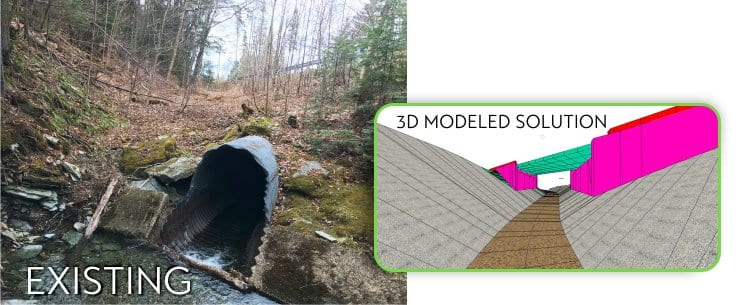
The biggest improvement for 3D modeling the past 20 years are the visualizations. In the past it would take additional software and potentially months of time – depending upon the project size — to develop a picture to use for a public presentation. With the current software, visualizations, pictures, models, and even movies/videos, are a beneficial byproduct of developing the 3D model instead of a separate task. Additionally, the public doesn’t always understand the construction plans, but everyone knows what a road and a bridge look like; they drive on, over, or under them every day. By having the 3D model, we can “place” them at their point of interest of a proposed improvement and show them this is what the roadway looks like today, but this is what it could look like tomorrow. This is a big advantage of using 3D models; they help take the guesswork out of what people imagine this new roadway will look like.
Efficiencies in Future Applications of 3D Modeling
The future application that will continue to revolutionize the process of rehabilitating or reconstructing a roadway will be on the construction side. One of the most cumbersome aspects of 3D modeling is that not everyone uses it or has the ability or know-how to use it. Right now, we design in 3D but then provide the results in 2D piece on paper or in PDFs in the form of plans, profiles, cross sections, details, notes, and more. Then, that design goes out to bid, the winning contractor then takes the 2D plans and creates their own 3D model to use with their construction equipment.
The same project gets created in 3D two separate times – once by the designer and then again by the contractor! A challenge for the AEC industry is transferring 3D models from designers to contractors. Having an understanding of the contractor’s needs and continually improving software helps us provide the best quality possible for construction. This process is evolving – thankfully.
There are also efficiencies to be gained by our clients. Many state transportation agencies are transitioning to asset management systems, where they have access to more intelligent information about their assets for maintenance and future decision making. This starts with developing 3D models that are transferable to the contractor, providing them the ability to add information about the product installed, the date it was installed, who installed it, who inspected it, what the maintenance routine should be, and all additional product information. The DOTs can then develop programs that ensure the infrastructure is maintained and kept in the best condition possible for years to come.
Arguably the coolest future use of the 3D model is placing it in the helmets of those doing the actual construction. As usual it starts in the construction of buildings, but Trimble and Microsoft have already developed the XR10 with HoloLens for construction purposes. The XR10 is a construction helmet capable of containing a 3D model allowing the individual wearing it the ability to see the design intent on the jobsite and empower them to make more informed decisions by giving models real-world context.
The Benefits are Innumerable
The benefits of 3D modeling in roadway design are innumerable and will only continue to grow over time. Hoyle Tanner has been responsible for pioneering some of its applications in our headquarter state of New Hampshire, and we plan to continue using it in innovative and new ways in all of our service areas. Infrastructure improvement projects are demanding and require experience working with existing technologies and a willingness to try new ones. Whether the project is a rural town road or a complex segment of the national highway system, our transportation professionals implement creative solutions for the success of every project.
Do you have a roadway in need of design or rehabilitation? Or a project requiring a creative technological solution? Contact me!
*It’s Hoyle Tanner’s 50th anniversary this year! Keep an eye on our Facebook, LinkedIn, and Twitter feeds for articles and anniversary news!