Catastrophic Rain
During summer 2023, Vermont was plagued with many rainy days. This put a damper on many outdoor plans in a state known for its natural beauty and landscape. This seemingly season-long rain event came to a head between July 10-11, when in some areas of Vermont, rain came down relentlessly over a 48-hour period.
Along the spine of the green mountains, it was common for adjacent communities to report 4-8 inches of rain during this period with a peak in Calais, Vermont where they reported 9.2 inches of rain. With this storm, many historic records were overtaken, including both rain on a specific day and monthly rainfall volumes. The city of Montpelier, the state’s capital, reported the greatest volume of rainfall on a single day at 5.28 inches on July 10th.
Since 1948, the record has only been reclaimed once, on August 28, 2011 with Tropical Storm Irene. Many Vermonters remember the damage done by Irene – a storm that created chaos statewide. Between the damage done to both public and private property, the state was torn apart, and in some places, damage from Irene still remains today. Similarly, July’s floods have caused widespread catastrophic damage and give warning about what is to come.
Looking back at these two storms and into historical data, it seems that larger storms like these are becoming (and will become) more and more frequent. This begs the question: what can we do about this?
Hoyle Tanner’s Involvement
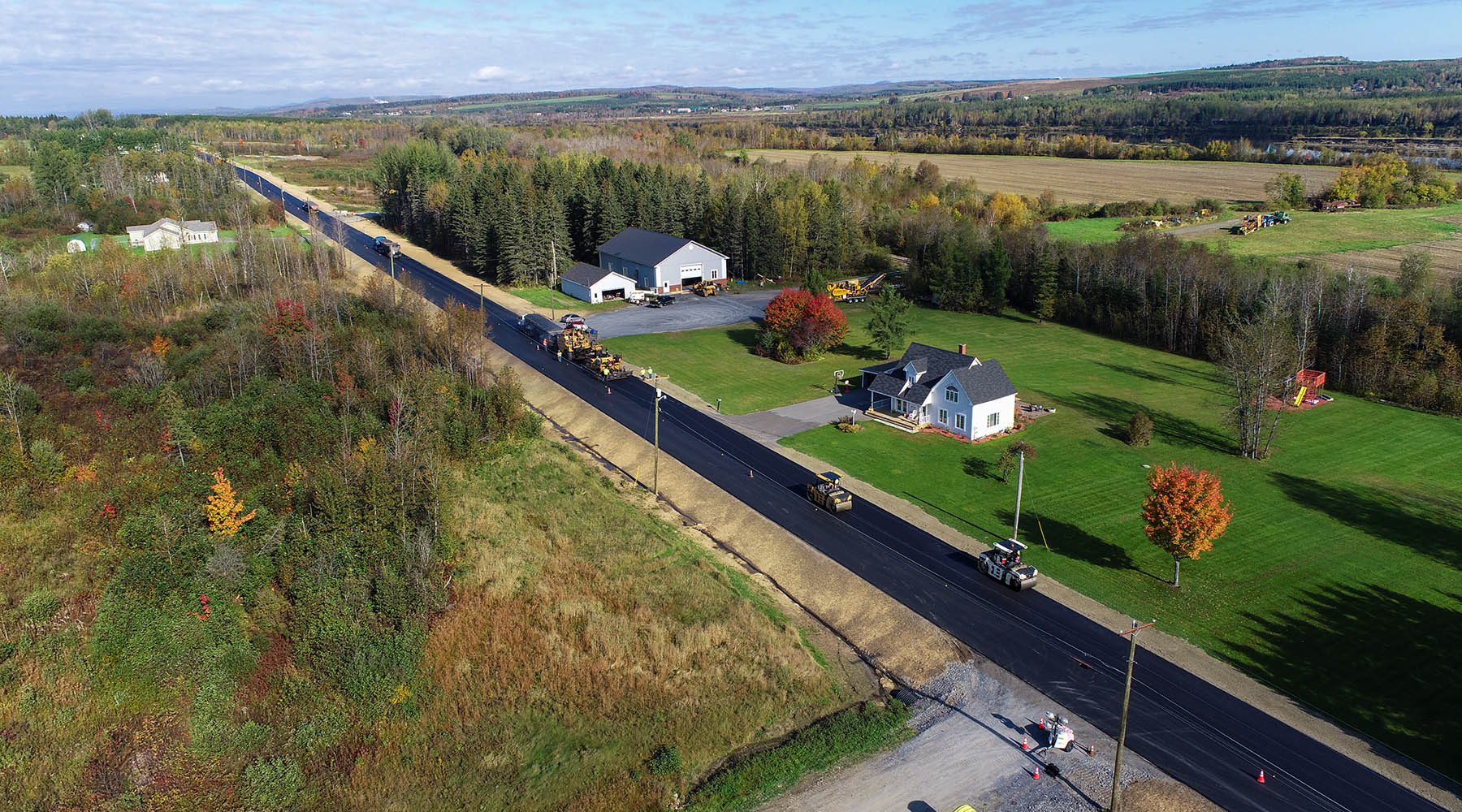
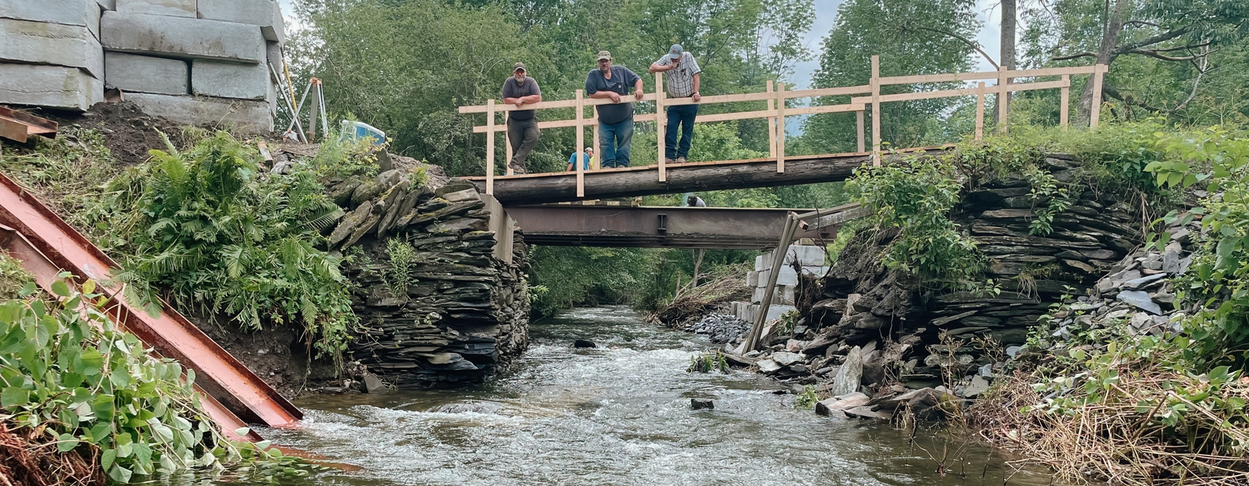
Following the month of rain, teammates in Hoyle Tanner’s Vermont office jumped to action, assisting towns throughout the state with bridge and roadway inspections, providing the expertise required to get these vital routes reopened.
Hoyle Tanner had two roles during this period:
- Inspect structures that were seemingly still intact to verify that they were safe to remain open.
- Design new structures to replace those that were no longer adequate for water flow or safe for vehicles traversing due to the flood damage.
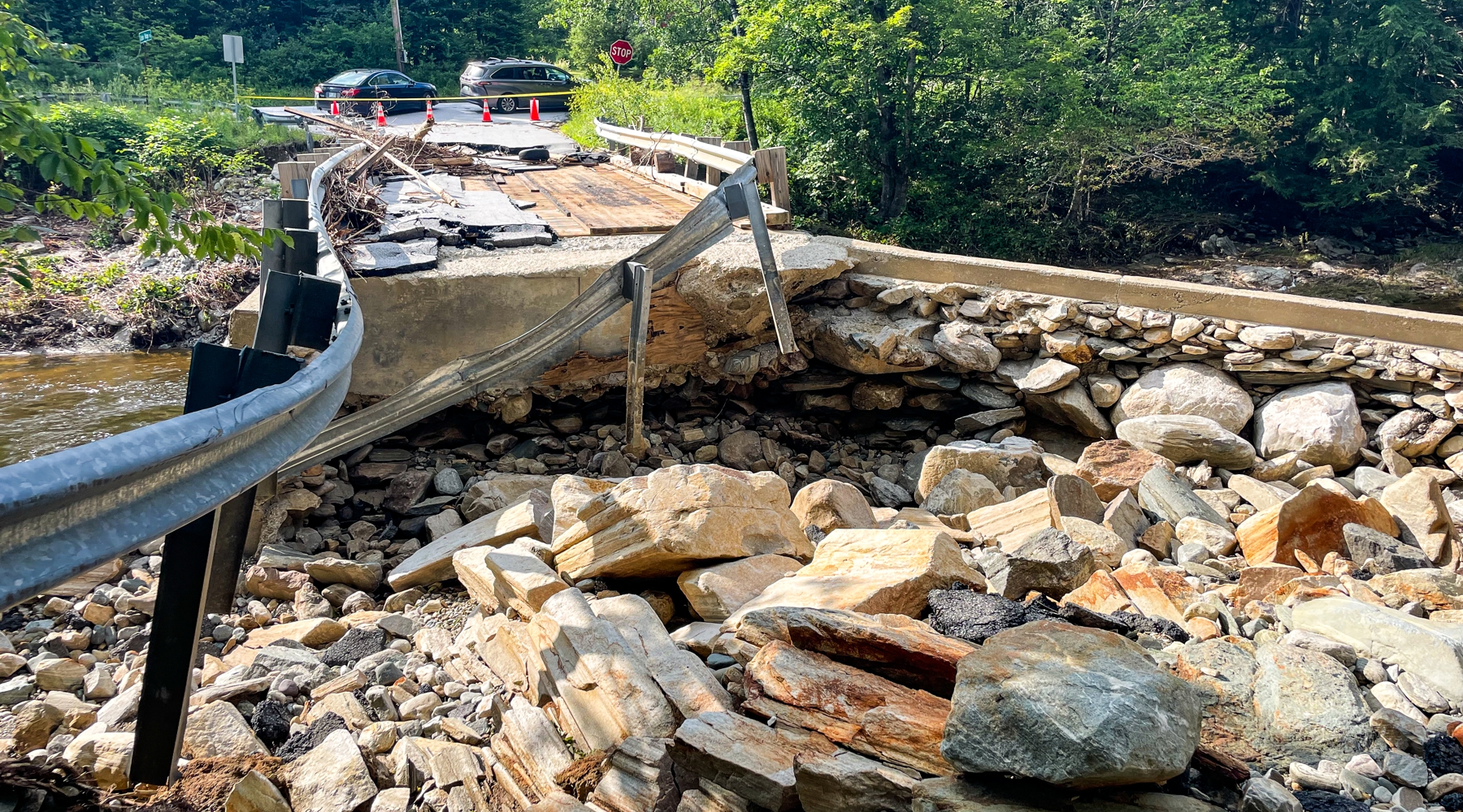
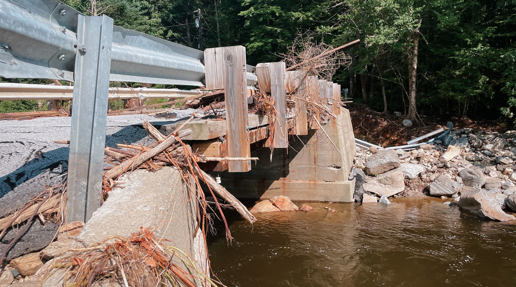
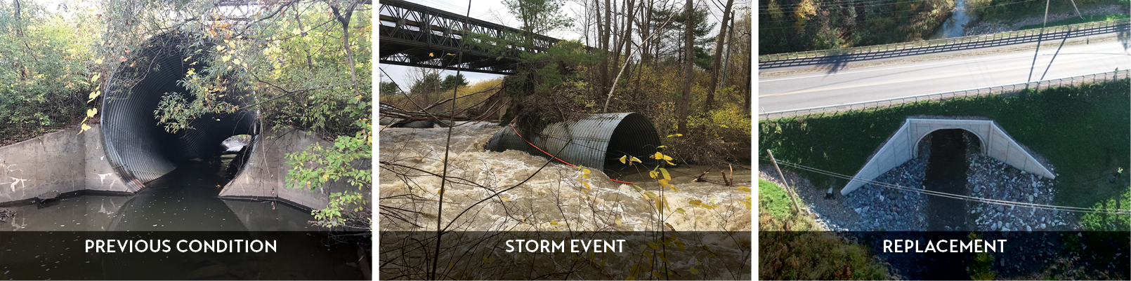
In some cases, bridges and culverts that were inspected remained intact, showing no signs of movement, scour, or, more generally, failure. In other cases, bridges completely collapsed, steel members dangling along the stream banks while the abutments stood firmly, out of the way of the intense flows. Even when the abutments were still in place, it was clear in many locations that the water level far exceeded the ordinary bank height, evident by looking at the plants in these areas, flattened by the flow.
Sometimes scour below or behind abutments was clear, caused by the heavy channelized flow in streams and rivers. In other cases, additional investigation (largely underwater) was required to locate and identify issues with scour around the abutments. In many cases where scour occurred, it was obvious that the stream width was restricted by the existing bridge or culvert causing fast moving water, at much higher levels than the ordinary highwater level (OHW), to hit the soil below and behind the abutments with much higher force than is normal, resulting in increased levels of scour.
The Vermont Agency of Transportation (VTrans) hired Hoyle Tanner staff to assess and redesign two culverts following July’s flooding events. In both cases, described below, the Vermont team identified issues with channel restriction, causing water levels to rise beyond the existing bank during this year’s storms.
Engineering a Solution: Fitting the Math to the Problem
The main takeaway we can gain from these recent storms is that water can and will find a way.
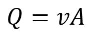
In many of the inspected cases it was clear that the natural waterway was restricted by the abutment structures when they were installed. This can be seen when looking at the stream width both up and downstream of the structure. In many cases if the stream width is greater upstream than it is at the bridge, it is likely being restricted. In cases of bridge failure and scour under and along the abutments, the location of the scour often occurred in line with the edge of stream upstream of the structure. Restricting of the waterway also results in an increase in velocity right at the structure, encouraging further damage. This relationship between waterway area (A, the cross-sectional area of the stream), velocity (v) and flow rate (Q) can be examined using the equation: FLOW RATE = VELOCITY * AREA
In the case where the area of flow (in our example, we will examine width as our main controlling variable of the area) is reduced by restricting the stream, and flow rate stays the same, you can expect increased levels of velocity between the abutment structures. Under normal conditions, this is fine because structures are oftentimes designed to resist scour that occurs under normal circumstances.
Relating this same relationship to compare a stream’s characteristic under normal conditions versus during a large storm event: an increase in flow rate, Q while maintaining the same area, A between the bridges abutment structures, you can again expect an increase in velocity of water, v. The large changes to the velocity are what tend to destabilize these structures and prompt repairs and closures.
Being in a predominantly rural state, with large areas of land sparsely inhabited, it becomes a challenge to replace and repair structures like these for a few reasons:
- Sometimes they only serve a small portion of the community, in some towns with populations less than 1,000 it doesn’t always make sense to build a $1 million bridge to connect three homes to the roadway network.
- They are so common and don’t see that much use, because Vermont is such a mountainous state, small residential bridges are commonplace in some towns. With so many small bridges, built to withstand less load, it puts a large strain on municipal governments to replace and repair so many small bridges.
- Municipal budgets are not robust enough to handle all of these repairs. With only 500-1,000 residents in some towns, building a bridge that costs millions of dollars has a direct and intense impact on each of its residents in the form of taxes. Especially in cases where a structure does not benefit the whole town, this can be a hard sell to residents.
What does this mean for the future of Vermont bridges and culverts? Resiliency is priority.
It means that in redesign and repair, resiliency must be one of the main priorities of the engineering team. In terms of redesign, resiliency may often times just mean that the structure does not interfere with the existing waterway. This gives it a much better chance of surviving and thriving when larger storm events inevitably occur. Maintaining widths and the natural path of the stream so that when velocity does increase it does not impact the structural integrity of the structure and earth surrounding it.
This also means upsizing structures where feasible to allow for enough freeboard clearance and flow capacity to withstand larger storm events. Erosion control measures can also be taken to help mitigate the impacts of these increased velocities such as armoring stream banks with appropriately sized stone.
One thing to keep in mind while designing these structures, though, is budget. Oftentimes, especially when designing culverts and bridges for smaller municipalities, their budgets are not large enough to accommodate projects that fix every issue. This means that a compromise must be met to make the best product within these parameters. This may mean reducing the level to which stormwater is managed (ex: designing for a 2-year storm versus a 100-year storm), or in some cases helping the town pursue additional funding sources to go toward this project.
Funding the Future
Even before Vermont’s major flooding events of 2023, there were funding sources promoting the design of infrastructure that could withstand storm events of the future and have long lifetimes. With the goal of building more resilient infrastructure, the United Stated Department of Transportation (USDOT) and Federal Highway Administration (FHWA) offer a variety of competitive grant programs used to fund transportation projects with a focus on building for the future.
The Rebuilding American Infrastructure with Sustainability and Equity (RAISE) Grant provides grants for surface transportation infrastructure projects that will have a significant local or regional impact (aka Local and Regional Project Assistance).
The Promoting Resilient Operations for Transformative, Efficient, and Cost-saving Transportation (PROTECT) Discretional Grant provides grants for activities that enable communities to address vulnerabilities to current and future weather events, natural disasters, and changing conditions, including sea level rise, and plan transportation improvements and emergency response strategies to address those vulnerabilities.
Federal Emergency Management Agency (FEMA) – mostly known for its disaster relief efforts – has supported pre-disaster mitigation since 1997. Until recently, communities only had the opportunity to apply for grants following a major storm event after they are able to perform an engineering assessment. Through its newly-instated BRIC program (Building Resilient Infrastructure and Communities), FEMA helps communities with emergency preparedness, directly relating to building more resilient infrastructure. For more information regarding the FEMA BRIC program see: FEMA BRIC Program: Addressing Bridge & Culvert Needs (hoyletanner.com)
Timeline on Funding
In the case of Vermont’s summer storms, FEMA offers funding towards emergency response through its Public Assistance (PA) grants. Once an area receives the Disaster Declaration process, the applicant (state, territory, tribe, local government, etc.) can apply for either emergency or permanent work. Applications must be submitted within 60 days of the Recovery Scoping Meeting to report all disaster-replated impacts. Emergency work (debris cleanup or emergency protective measures) must be completed within six months, while permanent work must be completed within 18 months, though the applicant can submit requests for a time extension. The scope and anticipated cost of the repair work is submitted to FEMA for review and validation. Once all parties are in agreement on the scope and cost, FEMA obligates funding for the repair work and monitors the work via project status updates until the project is formally closed out following completion of the work.
Here for the Storms & the Cleanup
Our professionals live and work in the New England region, along with Florida. We care about the region’s infrastructure and how it affects daily lives. We’ll be here during the storms and we’ll be here to help with the cleanup afterwards, from repair to funding to ribbon cutting. To learn more about our bridge, roadway and traffic services, visit our website. Please reach out to me if you have any questions about our emergency repair work!
*It’s Hoyle Tanner’s 50th anniversary this year! Keep an eye on our Facebook, LinkedIn, and Twitter feeds for articles and anniversary news!

!["[At Hoyle Tanner] there is a strong encouragement to keep growing professionally, and no one hesitates to help when you have questions or are learning something new. That positive approach to development creates an environment where people feel comfortable challenging themselves and building new skills." - Marko Salih](https://hoyletanner.com/wp-content/uploads/2026/07/Featured-Images_Marko.jpg)